Am in Milan for a rest and resupply day - mainly wahing and drying things! Last week has ben not ideal weather, in fact has rained most of the time. I needed to make up a route anyway to cut across from the vicinity of the yellow via alpina trail by Bolzano to the vicinity of the red trail by Tirano, so not a bad week to be putting together a not-quite-so-high-up route. The challenge is then to identify something that is suitable for the conditions but isnt just walking along the main road. (as commented previously, if I want to do the whole trip in the available time, then probably need to progress in some way most of the time, regardless of weather). This isnt helped by the Kompass Italian maps seeming rather less consistent on the trail marking than the Kompass Austrain ones - minor road / track in particlar seems to signify a wide variety of things, in one case being non-existent and in one case pretty much a high street, with everything in between. All in all have managed to put a good route togteher, with only a few very short sections of scurrying along the main road to reach the next track! There were some very satisfying bits also, managing to hit the high points at the breaks in the cloud - M Roen next to Bolzano, crossing the Passo della Forcola at the northern end of the Brenta dolomites, and also the high roads traversing the hills SE of Tirano (tarmaced and so a bit hard on the feet, but certainly no traffic and at just that right intermediate altitude to get superb views of everything).
Arriving in Tirano and in need of a night indoors to dry out, the whole town was full (tried 7 places) and no campsite. Therefore spent a wet bivvy and got the 6am train to Milan where I spent yesterday / last night snoozing and washing clothes. Off shortly for the usual map shopping, post last set of maps home, buy food, etc as always before back to Tirano. Might also look for some boots, have been doing the trip so far in lightweight walking trainers, very light and confortable and grippy but definitely limited ability to keep your feet dry in consistent wet conditions. Will also be doing more high level walking from here on (assuming the weather improves! forecast currently looking ok...) so more snow likely crossing likely.
Plan from here is to follow the red via alpina trail (weather and snow permitting) to Biasca, from there will have to see what date I arrive and work out a route on that allows me to get to a train station somewhere for meeting up with Gill for a long weekend start of July.
Languages also changing as I go of course. Was just srating to remember enough German when I crossed in Slovenia. No Slovenian but as I was only crossing the corner of the country for a few days have got by. Must get hold of an Italian phrasebook and pick up some Ialian - so far however, have been in aprts of
There is now a link to this blog also on the via alpina website...
http://www.via-alpina.org/en/page/754/and-those-who-are-setting-off
Monday, 21 June 2010

Monday, 14 June 2010
Rest day in bolzano
Day later in Bolzano, everything washed and fixed and ready to go again, and in possession of maps, food etc for the next stage. Its quite tricky slecting the maps for a make it up yourself stage, as I'm not totally sure which way i want to go until i have the studied the large scale map plus all the ones that follow i in a prticalr direction. Have therefore been standing in shops with my european road map, folding and unfolding various maps and working out which follows which! Anyway all set, without having bought too many excess maps (although still probably the main source of unnecessary weight in my bag), next aiming point Tirano.
Sunday, 13 June 2010
Bolzano - overview so far
Am in bolzano and have internet access again. And, at an estimate, have now walked about 1000km, hurray!
Have not done much apart from walk, eat and sleep - therefore tired, but healthy and not particualr problems so far. Since my last post I have crossed into Slovenia and then Italy, across the Dolomites. Days have been getting longer, close to the kind of distances and ascents that I need to be doing to get all the way round (20 miles or so with anything up to 9,000 feet of ascent). Am starting to find the heat quite a challenge however - since about Lavamund in southern Austria it has been getting hotter and hotter, and in particular very often is totally still and humid - ability to walk uphill is very often limited by overheatibng rather than fitness. Very often getting through 4 or 5 ltr of fluid just during the daytime, and feeling the need to find more places to stay to find a shower (campsites good: have showers but can still get away early to beat the heat a bit). Also, there has been more 'mountainous' walking than previously. Most of the sections in Austria were relatively straightforward (apart from the snakes) and the difficulty could be pretty much expressed as x miles and y feet of ascent. Since then the route has been generally higher and rougher going: more rough ground and / or exposed paths, requiring more time and effort than previously. I therefore feel on balance rather less fit than a few week ago, but this is probably not the case!
Snakes - 7 so far, only one of them (a large, sleepy adder that gave me a bored kind of look and then curled up again) refusing to move from the path when I asked it too. Fortunately not too steep to go around!
The character of the trip has also been a bit different the last week or two. Previous to that my route pretty much followed the Via Alpina exactly, since Slovenia I have used it more as a general line but have made up my own route. Various reasons for this. As a general one, the Via Alpina was marked on all the Austrian maps but not always since, and with the instructions from the internet not always being definitve the route has felt generally less definitive. Then more specifically. In Bovec (Slovenia) I couldn't find any maps for cross border into Italy, so ended up follwoing a minor road (marked on my map of Europe!) to get to Resiutta in Italy. Next, buying maps which didn't quite cover the right sections, so choosing a very close but parallel route instead. Finally, choosing a few alternative paths in expectation of too much snow on a few of the higher passes.
Last one is significant. I have been looking ahead at the route and anticipating any sections that, in the event of my not being able to get through (snow, bad weather etc), would give significant extra milage to either retrace my steps and / or find an alternative route. Am starting to realise that this is quite a long trip (if that's not a foolish comment) - although I am certainly not taking a beeline route (several detours have been slightly longer than necessary in fact), I am definitely looking ahead and ensuring that I go ways where there are alternatives, so that I will pretty much always be progressing in some way shape or form. The trip would just feel too big otherwise. Similarly there will be days when the weather will be too bad to go too high (although so far have generally managed to fit rest days around these), likewise will probably have to push forward on lower routes on these days given the time constraints.
On balance I have ended up doing a bit more distance but a bit less ascent than expected. The VA descriptions seem to be accurate on distance but several times have overstated the ascent.
Whether I will go back to following the VA more exactly we will see - the next section in any case is planned as a make it up as I go, to join the VA red trail in the vicinity of Tirano.
Have not done much apart from walk, eat and sleep - therefore tired, but healthy and not particualr problems so far. Since my last post I have crossed into Slovenia and then Italy, across the Dolomites. Days have been getting longer, close to the kind of distances and ascents that I need to be doing to get all the way round (20 miles or so with anything up to 9,000 feet of ascent). Am starting to find the heat quite a challenge however - since about Lavamund in southern Austria it has been getting hotter and hotter, and in particular very often is totally still and humid - ability to walk uphill is very often limited by overheatibng rather than fitness. Very often getting through 4 or 5 ltr of fluid just during the daytime, and feeling the need to find more places to stay to find a shower (campsites good: have showers but can still get away early to beat the heat a bit). Also, there has been more 'mountainous' walking than previously. Most of the sections in Austria were relatively straightforward (apart from the snakes) and the difficulty could be pretty much expressed as x miles and y feet of ascent. Since then the route has been generally higher and rougher going: more rough ground and / or exposed paths, requiring more time and effort than previously. I therefore feel on balance rather less fit than a few week ago, but this is probably not the case!
Snakes - 7 so far, only one of them (a large, sleepy adder that gave me a bored kind of look and then curled up again) refusing to move from the path when I asked it too. Fortunately not too steep to go around!
The character of the trip has also been a bit different the last week or two. Previous to that my route pretty much followed the Via Alpina exactly, since Slovenia I have used it more as a general line but have made up my own route. Various reasons for this. As a general one, the Via Alpina was marked on all the Austrian maps but not always since, and with the instructions from the internet not always being definitve the route has felt generally less definitive. Then more specifically. In Bovec (Slovenia) I couldn't find any maps for cross border into Italy, so ended up follwoing a minor road (marked on my map of Europe!) to get to Resiutta in Italy. Next, buying maps which didn't quite cover the right sections, so choosing a very close but parallel route instead. Finally, choosing a few alternative paths in expectation of too much snow on a few of the higher passes.
Last one is significant. I have been looking ahead at the route and anticipating any sections that, in the event of my not being able to get through (snow, bad weather etc), would give significant extra milage to either retrace my steps and / or find an alternative route. Am starting to realise that this is quite a long trip (if that's not a foolish comment) - although I am certainly not taking a beeline route (several detours have been slightly longer than necessary in fact), I am definitely looking ahead and ensuring that I go ways where there are alternatives, so that I will pretty much always be progressing in some way shape or form. The trip would just feel too big otherwise. Similarly there will be days when the weather will be too bad to go too high (although so far have generally managed to fit rest days around these), likewise will probably have to push forward on lower routes on these days given the time constraints.
On balance I have ended up doing a bit more distance but a bit less ascent than expected. The VA descriptions seem to be accurate on distance but several times have overstated the ascent.
Whether I will go back to following the VA more exactly we will see - the next section in any case is planned as a make it up as I go, to join the VA red trail in the vicinity of Tirano.
Wednesday, 9 June 2010
Slovenia
Well Graham managed to get through the Slovenian Alps in about a week.
It's been a fairly mixed week, the weather has been a bit mixed.
There was still about 2m of snow on some of the higher passes which he was planing to take so there was a few changes in route.
Also he came down with a bit of a bug so had a rest day where he pretty much slept most of the day.
The light weight boots have also proved an issue, they were light weight, but maybe not quite up to the mileage / weather which this trip has given them. Still averaging about 20 - 25 miles a day - with the rest/ill day the only exception where he did 8 miles before breakfast (and then slept).
Also maps were not quite as easy to come by as Graham had hoped, a couple of days he's been using a 1:500000 map of Europe to navigate by. I can imagine how depressing it is to look at the map and see over the course of the day you've only moved a inch or 2 at the most. this section was on minor roads, but the views and scenery were still pretty spectacular.
Graham then crossed into Italy on 3rd or 4th June - 2 countries in only a month!! Pretty impressive stuff
It's been a fairly mixed week, the weather has been a bit mixed.
There was still about 2m of snow on some of the higher passes which he was planing to take so there was a few changes in route.
Also he came down with a bit of a bug so had a rest day where he pretty much slept most of the day.
The light weight boots have also proved an issue, they were light weight, but maybe not quite up to the mileage / weather which this trip has given them. Still averaging about 20 - 25 miles a day - with the rest/ill day the only exception where he did 8 miles before breakfast (and then slept).
Also maps were not quite as easy to come by as Graham had hoped, a couple of days he's been using a 1:500000 map of Europe to navigate by. I can imagine how depressing it is to look at the map and see over the course of the day you've only moved a inch or 2 at the most. this section was on minor roads, but the views and scenery were still pretty spectacular.
Graham then crossed into Italy on 3rd or 4th June - 2 countries in only a month!! Pretty impressive stuff
Thursday, 27 May 2010
Bruck to the Slovenian border
Graham is fairly getting on now, he is hoping to cross the border from Austria into Slovenia on Friday 28th.
So far communication has been pretty easy, he's phoned most days. Fingers crossed the mobile signal and solar charger combo will continue!!
The weather has remained hot, with Graham drinking 5L of water one day. Due to constraints with bivying he's been staying in huttes or B&B most nights, but is now thinking that he might have to start sleeping out, if for no other reason than to get an early start in the morning, have a long siesta at lunch time and walk into the cool of the evening.
He has come across quite a few snakes in the last few days, mainly adders. the 1st couple were dead but the last few days they've been alive - and happily hissing as they slither quickly away.
He has fairly been clocking up the miles now too, last Friday he walked 32 miles...... although 5 was trying and failing to find the hutte that he was hoping to sleep in that night. After that he had a well deserved rest day - but unfortunatly no internet was near at hand.
Today he did 9000ft of assent (more than 2 x Ben Nevis!!) He is pleased with his progress as he is now managing the miles and the assent which should keep him on track to complete the walk.
He is also quite pleased with how his German has come on - perfect timing to forget it all before needing in again in several months time when he heads into Switzerland.
Heading into Slovenia there could be some extra miles as the map is a larger scale than the ones he's been using in Austria.
So far communication has been pretty easy, he's phoned most days. Fingers crossed the mobile signal and solar charger combo will continue!!
The weather has remained hot, with Graham drinking 5L of water one day. Due to constraints with bivying he's been staying in huttes or B&B most nights, but is now thinking that he might have to start sleeping out, if for no other reason than to get an early start in the morning, have a long siesta at lunch time and walk into the cool of the evening.
He has come across quite a few snakes in the last few days, mainly adders. the 1st couple were dead but the last few days they've been alive - and happily hissing as they slither quickly away.
He has fairly been clocking up the miles now too, last Friday he walked 32 miles...... although 5 was trying and failing to find the hutte that he was hoping to sleep in that night. After that he had a well deserved rest day - but unfortunatly no internet was near at hand.
Today he did 9000ft of assent (more than 2 x Ben Nevis!!) He is pleased with his progress as he is now managing the miles and the assent which should keep him on track to complete the walk.
He is also quite pleased with how his German has come on - perfect timing to forget it all before needing in again in several months time when he heads into Switzerland.
Heading into Slovenia there could be some extra miles as the map is a larger scale than the ones he's been using in Austria.
Sunday, 23 May 2010
Some photo's from Bad Goisein to Eisenerz

The 1st sign post for the Via Alpina - A good sign amongst the many!!

A fine 'see' for a picnic

Who's that hiding there???? A common feature on the walk

The view from Weissenbach - and towards the next days walk!

Yet another picnic - one of my fav things about walking!!
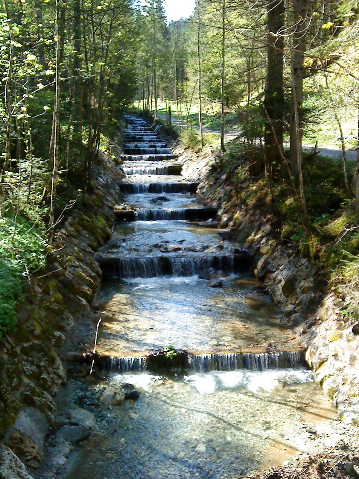
A fairly well structured stream.


A view of the eastern alps near Leoben

A lunch time stop at one of the mountain huttes, unfortunatly it was closed but we were all stocked up and able to make our own tea. Typical, just as we were heading off the guy came and opened up the hutte.............


A lunch time stop at one of the mountain huttes, unfortunatly it was closed but we were all stocked up and able to make our own tea. Typical, just as we were heading off the guy came and opened up the hutte.............

Looking back down to Radmer
Tuesday, 18 May 2010
Eisernerz to Bruck
Five days further on and am at Bruck...not far from Leoben where Gill got her train 5 days ago, but properly here (having walked), rather than just on a day off to see Gill off. Unfortunately since then the weather has not been the best...has changed from just bad higher up to extremely bad at all levels!
I headed east from Eisenerz across the south side of the Hochschwab range, initially with some good views of the impressive limestone cliffs immediately above, but these soon disappearing unfortunately, leaidng to slow picking out the path in the mist where snow patches covered the markers. As the weather got worse my route followed lower routes, until I reached Seewiesen at the east end of the Hochschwab. My original idea had been to climb up from here to the east end of the plateau, and, ideally, gaze eastwards at dawn from a high bivvouac. However, by now the forecasted 130 km per hr wind with fresh snow down to 1200m was fully in evidence, so instead just took a rather misty photo from the baclony of the Seewiesen Gasthof and set off directly on my southward leg the following morning. Camping in the valley the following night tested out my tarp (10' square nylon sheet which is pitched using a walking pole at each end, not unlike a tent flysheet with open ends) in high winds, having to repitch it lower during the night. Back rather sore the following day proabably from grabbing at tarp edges as they blew away and crawling around under it very low pitched (for wind resistance). Therefore a rest day and resupply in Bruck, plus hot showers and ibuprofen, should avoid any problems.
Have covered 70 miles in about 4 days which is encouragingly close to the distances I will need to be covering, although not as much ascent or rough going yet as I will need to be capable of. Very encouragingly the fresh snow doesn't seem to have reached these hills, presumably being shielded by the higher mountians to the north and west. If feasible, I'm planning to follow the high (up to around 2000m) ridge of the Gleinalpe which runs directly southwest from here to rejoin the Via Alpina between Knittelfeld and Gaberl. From there on plan is to follwo the Via Alpina more closely, depending on weather conditions and degree of waymarking, we shall see...
I headed east from Eisenerz across the south side of the Hochschwab range, initially with some good views of the impressive limestone cliffs immediately above, but these soon disappearing unfortunately, leaidng to slow picking out the path in the mist where snow patches covered the markers. As the weather got worse my route followed lower routes, until I reached Seewiesen at the east end of the Hochschwab. My original idea had been to climb up from here to the east end of the plateau, and, ideally, gaze eastwards at dawn from a high bivvouac. However, by now the forecasted 130 km per hr wind with fresh snow down to 1200m was fully in evidence, so instead just took a rather misty photo from the baclony of the Seewiesen Gasthof and set off directly on my southward leg the following morning. Camping in the valley the following night tested out my tarp (10' square nylon sheet which is pitched using a walking pole at each end, not unlike a tent flysheet with open ends) in high winds, having to repitch it lower during the night. Back rather sore the following day proabably from grabbing at tarp edges as they blew away and crawling around under it very low pitched (for wind resistance). Therefore a rest day and resupply in Bruck, plus hot showers and ibuprofen, should avoid any problems.
Have covered 70 miles in about 4 days which is encouragingly close to the distances I will need to be covering, although not as much ascent or rough going yet as I will need to be capable of. Very encouragingly the fresh snow doesn't seem to have reached these hills, presumably being shielded by the higher mountians to the north and west. If feasible, I'm planning to follow the high (up to around 2000m) ridge of the Gleinalpe which runs directly southwest from here to rejoin the Via Alpina between Knittelfeld and Gaberl. From there on plan is to follwo the Via Alpina more closely, depending on weather conditions and degree of waymarking, we shall see...
Subscribe to:
Posts (Atom)